How to plan your bike route
Contents:
Planning your bike route isn't just about getting from point A to B. There’s a lot of personal choice that goes into what type of ride you want to have and there are many things to consider when it comes to planning your two-wheeled journey.
Design your ride with safety in mind
Cycling is a great way to get around the city, whether you are out for a recreational ride, running some errands or commuting to work. With a little planning you can design a route with safety in mind. Toronto has many types of bicycle infrastructure that can be separated into a few general categories. You can review them here. Now let’s see how to use that infrastructure and create a safe and enjoyable ride that works for you.
What’s your reason to ride?
Choosing a comfortable route for you will depend on a number of factors. Parents out riding with kids will have different criteria than those making a daily dash to work. Consider your personal preferences, comfort with traffic and available time. A meandering route through the city’s ravine network may be great for a Sunday cycle but may be too time consuming when you have to pedal it out to make a meeting.
Match your needs with Toronto’s network
The Toronto Cycling Map is a great resource for planning a personalized route. Why is this interactive map so great? Because it lets you select the type of cycling infrastructure you prefer to ride on. Click on the arrow box in the top left and then select only the cycling infrastructure you want to see.
To build a route, select the types of infrastructure you’re comfortable using and work from there. “Cycle tracks”* and “multi-use trails” are a good place to start if you’re fortunate enough to be travelling near these routes.
It always helps if you are familiar with the roads and trails up for consideration. That way you can quickly eliminate route sections you may want to avoid such as those with higher speed traffic, heavy congestion, bus and streetcar routes, on-street parking and other potential hazards, including streetcar tracks.
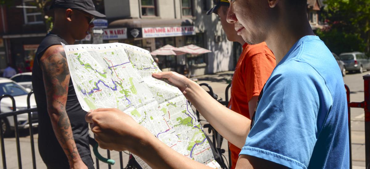
If paper is more your thing, print versions of the Toronto Cycling Map are available in Toronto Public Libraries, Civic Centres and at Cycle Toronto events and outreach tables.
*Note: The City uses the legal term “cycle track” which most closely resembles our definition of “protected bike lane” but is not necessarily identical. For instance, the Bloor St W bike lanes are “cycle tracks” but there is no protection on the north side of the street from Bathurst St to Walmer Rd.
Mapping apps
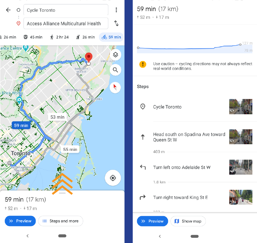
There are dozens of popular apps designed to get you where you’re going. However, even the best programs have drawbacks, so keep your own preferences in mind. Here are a few that we like to use when planning a new route. All of these programs display elevation change along your route, which can be helpful if you’re trying to find a flat route north! Compare different routes to see how the elevation changes. Pay attention if you have to cycle in and out of a ravine - it may be a steep climb out!
Note that some of these apps have paid versions with additional features, but all features we refer to are available in the free version.
Ride with GPS
Ride with GPS is designed specifically with bike riders in mind. There are loads of options available to plan your route and lots of useful information for bike riders, like elevation change, that automatically show up. You can even use the Google Maps background you're familiar with without having to go through several steps just to get to the bike stuff (see Google Maps section).
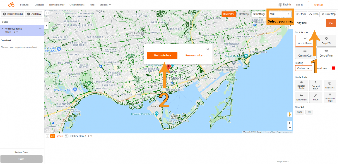
1. Search for a place to start your route.
2. Click "Start route here"
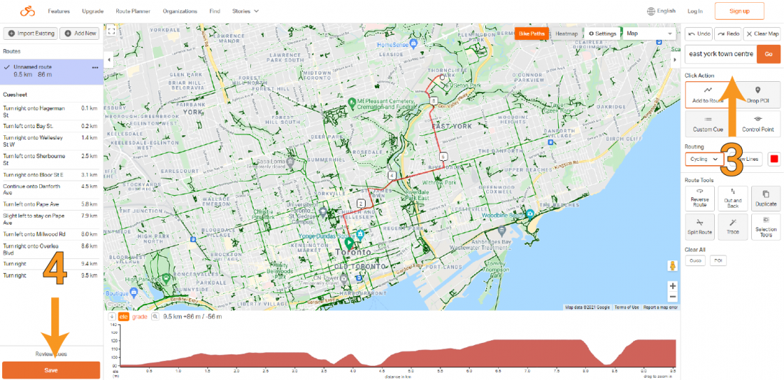
3. Search for your destination and Ride with GPS will give you a recommended route. You can adjust it in many ways to suit your own tastes.
4. Click "Save." You'll need a free account to save your route.
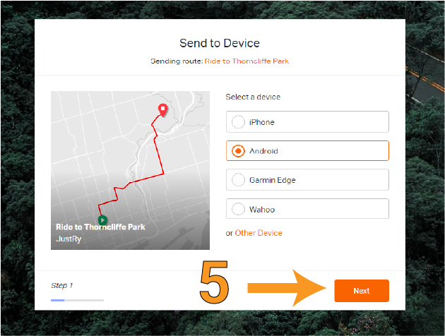
5. After you've saved the route you can access it with the desktop app any time or you can send it to the mobile app or other GPS devices in just a few clicks.
Google Maps
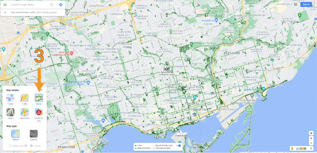
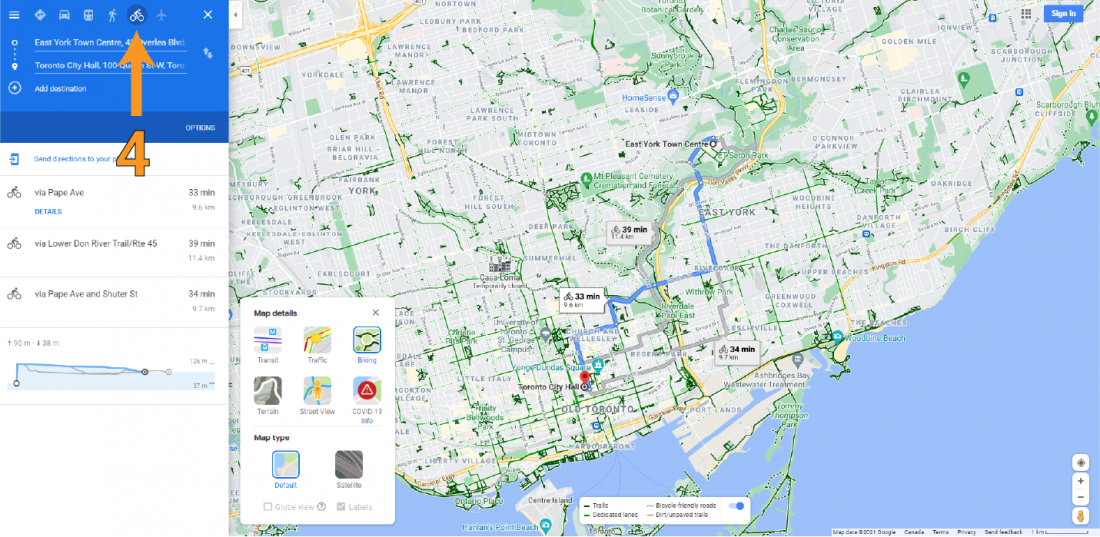
Many people already have this installed on their phones and it has options for bike routes that make it handy and easy to use. Google Maps also provides additional suggested routes that aren’t always present on the City of Toronto’s Cycling Map. This can be helpful when trying to pick the best route on a street that doesn’t have cycling infrastructure. Watch out for the brown lines - they are unpaved trails and can sometimes be closer to offroad mountain biking trails at some points!
An added bonus is that Google Maps offers multiple routes by default.
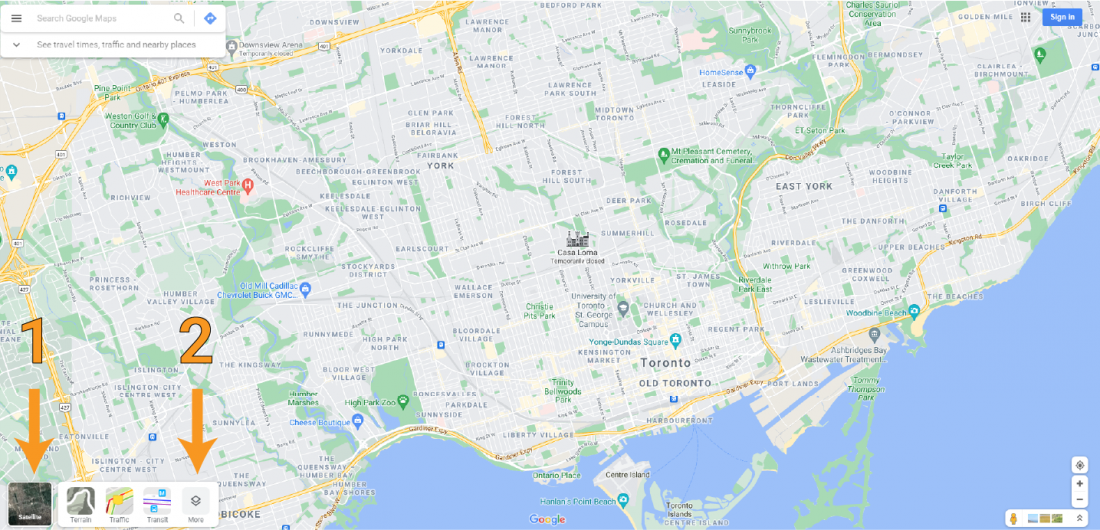
Screenshots of desktop version of Google Maps with arrows highlighting how to turn on bicycle routes.
Screenshots of Google Maps mobile version showing how to reveal elevation.
OsmAnd
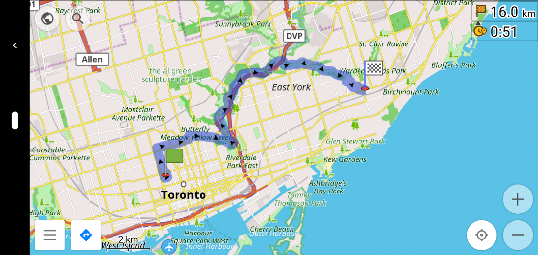
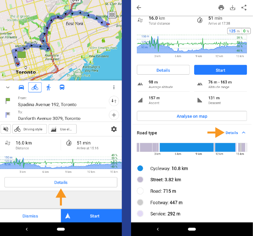
Bike infrastructure isn’t as apparent with OsmAnd as it is in Google Maps even with “cycling” set as the base profile. Key features include being able to select your “driving style” and easily downloading maps over wi-fi so they are available without phone signal. You can also see what types of road you're being directed onto and how long you’ll be on them. However, there is no desktop version of OsmAnd, so you'll need to use your phone.
Screenshot from OsmAnd in horizontal orientation showing route from Cycle Toronto to Danforth Ave and Victoria Park Ave.
OsmAnd route from Cycle Toronto to Danforth Ave and Victoria Park Ave in vertical orientation showing how to find road details.
Test your ride
Once you have a route you’d like to try, go for a test ride. Pick a quiet time when you won’t be encumbered by traffic congestion so you can take your time and adapt your route as needed. Be sure to take note of any segments where you don’t feel comfortable and plan to look for alternatives. The more you can get out and explore on your bike, the more informed you will be about your options. Besides, it’s always fun to discover what new routes have to offer and share them with your friends.
If you’re going somewhere new and don’t have the time for a complete test ride, leave a few minutes early. If you hit a stretch that makes you uncomfortable, you can detour through side streets and still make it on time.
To sum it up:
- Make it yours: consider your personal preferences, comfort with traffic, and available time when choosing your route.
- Maps are your friend: use the Toronto Cycling Map to identify the different types of on-and-off-road infrastructure.
- Know your way: take advantage of free route-mapping tools to discover paths or connections that could take your route to the next level.
- Testing, testing: If you can, pre-ride your planned route during a quiet time of day.
- Safety first: Review your rights and the rules of the road so that you keep yourself and others safe and you roll through the city.
Additional Resources:
- Toronto Cycling Handbook and Family Edition
- Winter Riding Tips
- Shoulder Season Riding Tips
- StartCycling.ca
This article was based on a piece originally written for Cycle Toronto by Holly Reid.
If you value the work Cycle Toronto does, please consider becoming a member. Our members give us a strong voice at City Hall, allow us to deliver Street Smarts educational outreach, run cycling events, workshops and more. Learn about becoming a member.
Subscribe to our mailing list to make sure you don’t miss any updates.
Check out more cycling resources
Lead photo by Nicholas Jones

